Land Trust Opens New Trail
Pine Mountain Hike Is Accessible for All Ages
By David Beers

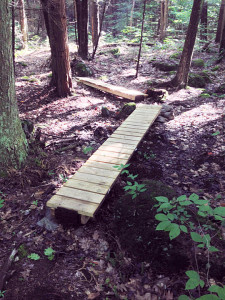
A bridge over a muddy section of the trail, built by the Norfolk Land Trust.
In 2013, the Norfolk Land Trust purchased 311 acres of forestland north of the Mad River from the Girl Scouts of Connecticut. Over the past three years, Land Trust volunteers have been developing an extensive trail system on the property that connects with the long-established Tait section of the Billings Trail along the rail bed. This property and the trail network are now open and ready for exploration.
To get to the trailhead, take Route 272 south for two miles, veer left onto Winchester Road and then take the next left onto Grantville Road. About a half mile farther along, on the left, is the trailhead. If you cross the bridge over Smith Pond, you’ve gone too far: turn around and drive back 100 feet to the trailhead. The trailhead has a break in the guardrail and off-road parking for about two cars. There is also a sign, a metal gate and some paper maps in a plastic dispenser. Drive slowly, because the speed limit is 25 mph, and it’s easy to miss.
This hike is three miles round-trip and takes about 1.5 hours. The hike starts on the flat, wide abandoned rail bed of the Tait Trail. This trail has white blazes and continues 1.5 miles to the intersection of Route 272 and Winchester Road. To get to the Pine Mountain trails, it is an easy walk, cross-country ski trip or bike ride for half a mile, with lovely views of Smith Pond and its associated marshes just to the east of the trail. The Land Trust makes this walk even more enjoyable by regularly mowing a wide swath along the trail.
The Pine Mountain Trail swings off and down a hill to the right (north) of the Tait Trail. This trail intersection is difficult to discern because the Pine Mountain Trail is on an indistinguishable old woods road, with orange and white trail blazes that are few and far between at the intersection.

In less leafy seasons, there are excellent views from the top of Pine Mountain.
The Pine Mountain Trail immediately drops down to a beautiful new wooden bridge over the rocky Mad River. Within 100 feet of the river crossing, the trail intersection appears, with an orange-blazed trail heading off to the left (the Scarlet Tanager Trail) and a white-blazed trail to the right (the Pine Mountain Trail). I took the white-blazed trail on my mountain ascent and then descended on the orange-blazed trail to make a loop.
The white-blazed trail has some new wooden bridges over a muddy section that greets you right at the trail start. Most of the trail follows old logging roads. After an initial moderate ascent, the trail flattens out. At 0.4 miles, a newly cleared unblazed trail heads off to the right (east). This is the trail to Pine Mountain’s east summit, which, at an elevation of 1,600 feet, is 40 feet higher than the west summit. As soon as this East Summit Trail is blazed with paint, it will be worth checking out.
After this trail intersection, the trail remains level for quite awhile as it tunnels through a thick young forest of saplings and then opens into glades of ferns and flowering mountain laurel shrubs. This section of trail is a refreshing change from the usual mature forests of most trails in Connecticut. It was also on this section that I noticed what seemed like a gazillion newts meandering across the trail at this time of year.
Soon another moderate ascent begins. The trail leaves the old logging road and becomes much more narrow and snaky. When the trail levels out again at the top of Pine Mountain (western summit), the trail darkens in a hemlock forest. I saw one pine tree, but the others were probably logged off years ago.
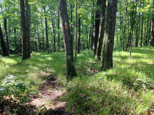
Up until the remote top of this mountain, there are no stone walls, but the summit reveals a beautifully well-constructed stone wall alongside the trail. Upon leaving the stone wall, the trail curves left (east) into a grassy oak glade that slopes to the east, revealing quite a view to the east and south when the leaves are off the trees. This is a good place to take a snack or water break.
This summit oak glade is 0.75 miles from the last trail intersection, and it is where the paint blazes switch from white to orange, signifying the beginning of the Scarlet Tanager Trail down the mountain. The descent begins as a series of moderately steep switchbacks until it levels out down in the mix of fern glades and saplings tunnels mentioned earlier. There is one last moderate descent to the intersection with the white-blazed trail at the Mad River.
The white-blazed trail has a more gradual ascent, lending itself to some backcountry skiing, but not on the switchbacks of the orange-blazed trail. Overall, the ascents are short in duration and moderately steep. This hike can easily be done by both young and old. Residents should put a visit to the eastern summit of Pine Mountain on their short list of things to do in Norfolk in the coming months.
Photos by David Beers.
