It’s Only Natural—October 2016
Geography Over the Guardrail
By Hans M. Carlson
I am a connoisseur of secondary roads, because they give the up-close view of the human and natural landscape that I have highlighted so often when writing about things in and around Norfolk. Interstates by contrast are not really of the places they cross, and for this reason I do my best to avoid them. They leave me feeling separated in space and time, and missing most of what there is to see.
Sometimes there’s no choice however, and such was the case with driving to Minnesota this August. Speed meant more time canoeing the Boundary Waters, so I made peace with I-88, I-86, and I-90, and I have to say I gained some grudging appreciation for the macro view those roads offered. Even at 75 mph, the landscape tells a story.
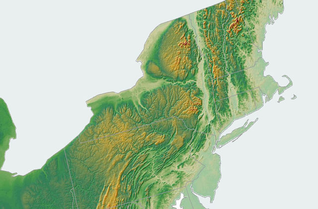
Driving west from Norfolk toward Albany means leaving New England, and there are great historic and cultural differences between these places, though they are not apparent over the guardrail. Crossing the Housatonic and Hudson, however, also means crossing a small section of the Great Valley of the Appalachians, and the visual changes in geography because of that are dramatic.
The Great Valley comprises features as far south as the Shenandoah and Tennessee Valleys, and as far north as the Champlain Valley, sitting in morning shade each day, until the sun crests the Green and Smoky Mountains—the Berkshires too. It’s the remnant of tectonic activity, and to a large extent separates the hard marbles, slates and granites that give structure to New England, from the ground-up sedimentary rock that makes up so much of western New York and Pennsylvania.
Our hills are the un-eroded remains of mountains thrown up when Africa ran over North America, beginning about 450 million years ago, when the Taconic Orogeny created something like the Himalayas here. The Acadian Orogeny, 50 million years later, repeated the show and another 100 million years later, the Alleghenian Orogeny pushed another massif to the sky. All this action created the heat needed to cook the sedimentary rock left from ancient seabeds into metamorphic rock. This left us with our familiar conical hilltops and crenellated ridgelines, when erosion and glacial activity moved most of the overburden into the oceans to the east.
Climbing out of the Hudson Valley going west is a different story. There, one is aware of not climbing the short, steep hills of the Berkshires anymore, but the long, rolling waves of the Appalachians. From the top of one of these ridges you can see range after western range of what’s left of the outwash plains of those ancient mountains. It’s one of the vagaries of glaciation that ice did not reach south of Buffalo, so where in New England we have bumpy ridges of hard metamorphic rock, this region is the reverse. Ridgelines here are flat and made of eroded rubble, where contour comes from deep valleys cut into softer, fragmented materials – a landscape of hollows and not hills.
The waves of geologic outwash subside moving west, like the ocean calming after a storm, and by Chautauqua you can feel Midwestern calm approaching. The transition happens somewhere around Erie, Pennsylvania. Interestingly, this puts you back into a postglacial landscape, though one without the history of tectonic up-thrust and erosion. This is a geologic landscape as quiet and earnest as the Midwest itself, where layered sedimentary rock still lies unchanged under deep soils deposited when the ice carved out the Great Lakes.
The country along the shores of Lake Erie and out into the flat farmland of northwest Ohio doesn’t offer the passenger-seat geographer much to look at, but starting in Indiana the glacier left a terminal moraine, a pile of debris that marks its furthest extent. This is of interest, because throughout the upper Midwest the Wisconsin Ice Sheet left familiar kinds of terrain, a landscape not identical but reminiscent of home.
The rest of our journey to northern Minnesota followed this glacial borderland. Like New England, this is a region filled with eskers, as well as kettles and kames, along with the moraines. On the edge of the prairie, kettles are often filled with forest rather than water, for the ice melted there far longer ago and many ponds have evaporated and filled with trees. As you approach the Canadian border, however, there are many places where things look more familiar. If you replaced the dominant jack pines with hemlock, there are ponds that would remind you of Tobey, and rocky terrain quite similar to Norfolk.

