Norfolk’s Mountaintop Views Just Got Clearer
State to provide signage describing scenic Haystack Mountain vistas

by Jude Mead
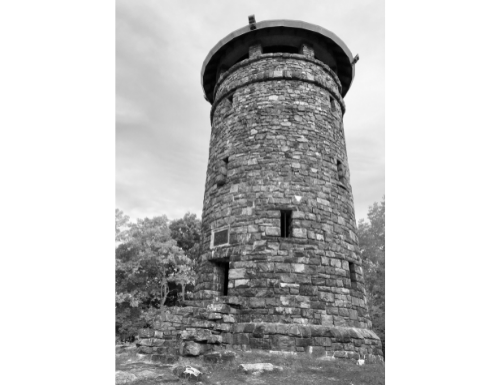
Haystack Mountain State Park in Norfolk offers many walking and hiking trails. The most popular is the mildly rigorous trek that follows a trail up the mountain to a stone observation tower with a 360-degree view of mountain ranges, lakes and historical town landmarks.
This breathtaking sight at the top of the tower is well worth the climb and many visitors peer out at the vista in wonder. Perhaps they are asking themselves, what are those mountains, lakes and historical town landmarks called? These questions will soon be answered, because the state will be adding identification signage to the tower this coming season.
The tower stands 34 feet high and sits 1,716 feet above sea level. Its history dates back to the late 1800s. Apparently, Robbins Battell, a Norfolk native, had an issue with a claim made by the Encyclopedia Britannica publication that Connecticut had no elevation over 1,000 feet. To prove that point incorrect, Battell hired his own surveyor who found several elevations of 1,000 feet or more, one of them being Haystack Mountain.
Battell then purchased the summit in 1886, although his daughter, Ellen Battell Stoeckel, sold the land to the state of Connecticut in 1917 for $1,200. She later donated $50,000 to the state to build the stone tower, which was constructed in 1929, allowing the public to enjoy its spectacular views. Now visitors will soon know the names of the landmarks they are viewing.
Stephany Dumond, at the Department of Environmental and Energy Protection of the State of Connecticut, is enthusiastic over the signage project. “We have been examining the possibility of designing signage for the tower for a while. It is a process, however, and had to go through a chain of command for final approval,” she said.
According to Dumond, when designing the signs they had to consider that Haystack Tower was an historic site. In 1993 Haystack Mountain State Park was added to the National Register of Historic Places. “When a building is an historic site, the design and placement of signage must follow the state’s guidelines,” she said.
Dumond had to think about the architecture of the building, as well: “The type and size of the signs also depend on the structure of the building. Because the tower is not enclosed, we had to come up with what would work best there.”
The final decision was to install small laminated signs that detail the specific landmarks that can be seen from the tower in all four directions. On a clear day from this vantage point a person can see Canaan Mountain, the Lion’s Head, Bear Mountain, Round Mountain, Mt. Frissell, Race Mountain, Mt. Everett and many bodies of water, including Wood Creek Pond. To the east is Norfolk Village. “The laminated signs will be easy to look at and easy to maintain. They will include the history of Haystack Mountain, as well as all the visible landmarks looking east, west, north and south,” said Dumond.
She continued that in the near future visitors to Haystack Mountain will be greeted with still another new sign. “We plan to place this kiosk near the pond at the entrance to the park. It will include the history of Haystack Mountain along with the rules and regulations,” said Dumond.
