DOT Holds Norfolk Open House to Answer Questions on Route 44
Construction expected to take over four years
By Ruth Melville
In recent years, the Norfolk driver has been forced to learn patience—and that patience is about to be tried again. The long-anticipated project to replace the retaining wall on Route 44 west of town is officially underway, with an anticipated completion date of September 2028.
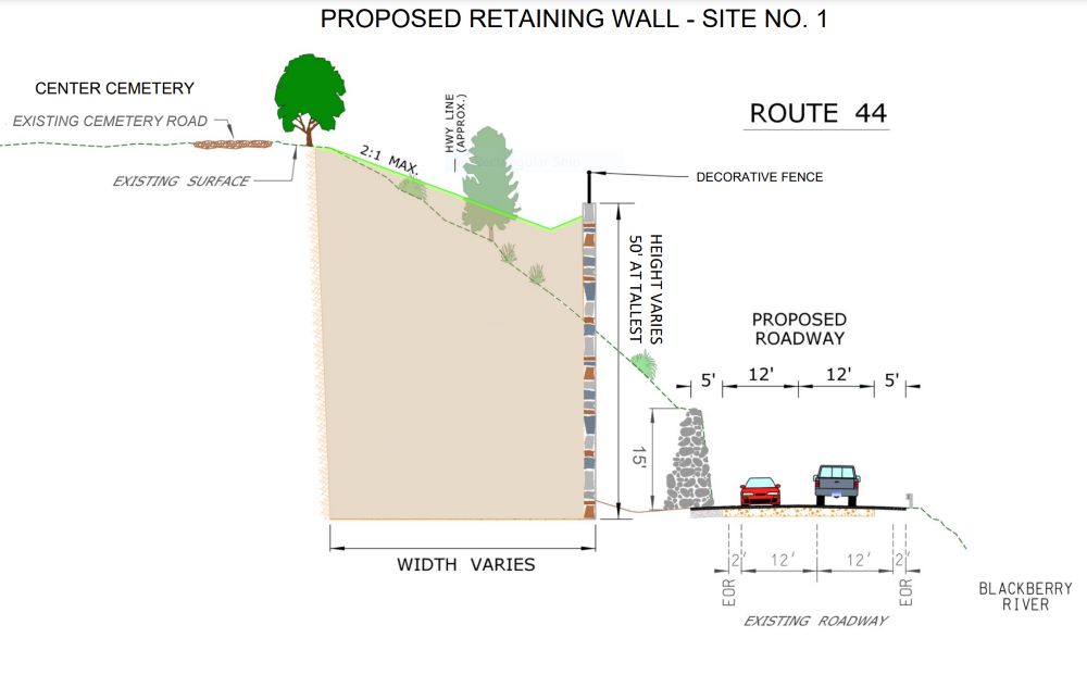
The goal is to stabilize the north slope along Route 44 (also known as Greenwoods Road West) and replace the existing rubble masonry walls, which have become weakened over time. A reconstructed drainage system will be installed on the slope to control the water coming down the slope from Center Cemetery.
The estimated cost of the project is $37 billion, with the funding to be split between the federal government (80 percent) and the state (20 percent).
On May 16, the Connecticut Department of Transportation (DOT) held an open house at the Hub on Station Place to introduce the construction team, lay out the stages of the project and answer questions from the audience.
Amy Hare, a project engineer for the DOT, hosted the meeting. She was joined by several engineers working on the project and representatives from the contractor, K Infrastructure Group.
Pointing to a diagram pinned up at the front of the room, Hare showed that, from west to east, there are three wall sections to be repaired: wall A, at the intersection of Old Colony Road and Route 44; wall B, a small section between walls C and A; and wall C, which is where the three-foot bulge is. The work will be divided into two sites, or staging areas, with site 1 being walls B and C combined, and site 2, wall A. Only one staging site will be worked on at a time.
During the construction season, roughly April 1 to Dec. 1, traffic on that stretch of the road will be down to one lane, controlled by timed electronic signals, detectors in the road and pavement markings. No work will be done during the winter, when both lanes will be open.
A system, yet to be chosen, will be in place to give emergency vehicles override over the signals. There will also be signs encouraging an alternate route for trucks, but Hare admitted that the proposed detour—roughly, south on Route 7 in Canaan, over to Goshen, and north up 272—is long (about 45 minutes driving time) and inconvenient, and that the DOT cannot enforce that trucks follow the detour.
The DOT’s Division of Highway Design has done a lot of advance work, taking into consideration the many aspects of the project, including analysis of the watershed area and the soil composition, bridge design, traffic design (signage, signaling, staging sites), environmental concerns (especially near Old Colony Road) and cultural protection of the historic cemetery at the top of the slope.
The project officially got underway on May 17, although prep work to relocate utilities has been underway for weeks. It is estimated to take over 1,000 days, the equivalent of five construction seasons. Reconstruction work will not start this season.
The original walls were constructed of rubble masonry, with not much to hold them together. Over time, erosion and the freezing and thawing of water moved material on the slope. One of the engineers noted that the steep 45-degree slope added passive earth pressure on the old walls and said that it was impressive that they’d lasted so long.
The new, engineered walls will be attached to the slope and anchored five to 10 feet into the ground. The slope will have better drainage, and the new walls will have drains at the bottom.
The DOT promises that the new walls will be aesthetically pleasing and match the surrounding area. The faces of the cement walls will have an architectural treatment to look like stone and will be subject to the approval of Town Hall.
In response to questions from the audience, Hare said that no blasting should be required, and the stone pillars at the cemetery will not be moved. Although the large oak trees on the slope will be taken out, the old—stabilizing—root system will be left in place. The slope will be reseeded, replanted and landscaped.
Water outlets into the Blackberry River will be upgraded, but otherwise the river will not be affected. The current rough, patched road surface on Route 44, caused by Aquarion’s work on the water mains, is to be milled and paved before any work begins.
As an additional benefit, once the project is finished, the road itself will be safer. Lanes will be increased from 11 to 12 feet wide, the shoulder will be wider, and there will be a six-foot buffer between the road shoulder and the wall.
Michael Selleck, co-chair of Norfolk’s Economic Development Commission and a longtime campaigner against traffic speeding through town, asked if the speed limit could be lower for the duration of the project. Hare said they couldn’t do that, but they will put up advance electronic warning signs, like the one that is next to the village green now.
During construction, representatives from the DOT will hold monthly progress meetings with Norfolk’s committee for the project: First Selectman Matt Riiska; Richard Byrne, the town’s emergency management director and sexton of Center Cemetery; and Bill Hester, from the Norfolk Sewer District.
Residents can keep up-do-date on the project by going to the DOT’s website: https://portal.ct.gov/dotnorfolk97-95. That website also has a recording of the original public informational meeting, where more details were presented than at the May 16 meeting. Regular updates will also be sent to the town website.
The engineers told the approximately 40 people at the Hub that the DOT understands that the town has been through a lot recently, especially with the damage caused by the oil tanker spill and the work on Maple Avenue, but that they are committed to making this new project go as smoothly for the town as possible.